

With the Kehlsteinstraße route having been decided, Bormann quickly turned to the idea of the construction of a reception house on the summit of the mountain. The aim was to have everything completed within two years – in time for Hitler’s fiftieth birthday on 20th April 1939 – and he was determined to do everything in his power to ensure that the planners, engineers, architects and builders delivered on time.
At the end of April 1937 the Reichsleiter met with Professor Roderich Fick, the Obersalzberg’s chief architect. Fick had all the necessary credentials: as well as being a professor at the Technischen Hochschule München, he had also designed the Munich residence of Hitler’s deputy Rudolf Hess. Without hesitation, the architect assured Bormann that the building of a permanent structure on the summit of the Kehlstein was more than feasible – and this was all that was needed to kick-start the project.
The Reichsleiter, the Tunnel and the Elevator
The decision to build the house immediately created another problem for the road planners – that of where and how it was supposed to finish. While Bormann was in favour of having the road go all the way to the summit and the entrance of the planned Kehlsteinhaus, Haupner and his team of experts were all agreed that the road should end at the parking area (Parkplatz) as originally intended. Their solution was a tunnel that bored into the rock face, and then an elevator shaft that connected the end of the tunnel with the summit.
When the proposals were presented to Bormann he initially demanded that the road go all the way to the summit, but on this occasion the engineers would get their way. Despite the Reichsleiter’s intransigence, a patient Haupner managed to present a clear and cogent set of reasons in favour of the tunnel and elevator – the biggest being that a road going all the way to the summit would ruin the dramatic visual effect.
Despite Bormann’s constant demands and alterations to the project deadlines work would accelerate at a pace through the summer and autumn of 1937, and then through the harsh winter months in spite of the weather – where much of the time was spent shifting and shovelling snow. With most of the mountain inaccessible to vehicles during the initial phase, all of the work had to be carried out using hand tools. A number of feeder roads had to be constructed in order to allow the safe movement of both men and materials, and makeshift camps and work huts were built to house those working on what was quickly turning into a twenty-four hour operation.
Haupner and his engineers would find themselves under constant pressure throughout the entire operation: often when faced with a new problem that threatened to delay or even derail the entire project, they would then be told that Bormann – for whatever reason – had tightened the deadlines or ordered additional work elsewhere on the mountain. While the Chief Engineer had no choice but to tell the Reichsleiter what he wanted to hear, he found it increasingly difficult to pass on these demands to the construction companies and contractors responsible for the work.
Not surprisingly, the relationship between the engineers and those responsible for undertaking the work slowly began to sour, and with the tightening deadlines came the ever-increasing fear of corners being cut. Unable to pass his concerns on to the unsympathetic Bormann, Haupner was left – quite literally – between a rock and a very hard place in trying to get the best out of the construction companies while at the same time managing the expectations of a man who knew very little about what the work actually involved.
The Südwesttunnel “Surprise”
The Südwesttunnel – also known as the Hochlenzertunnel or Recktunnel – was a typical example of the sort of additional work that landed on the desk of the Chief Engineer, in that it had never been planned or accounted for in the initial blueprints. The construction work on the road had all gone to plan until a short distance after the halfway point – just over three kilometres – when the engineers discovered rock formations that after analysis were deemed completely unsuitable for a stable road surface.
The solution to this problem was to stabilise the surface and bore under the rock, resulting in the construction of what would be the longest of the five tunnels on the Kehlsteinstraße.
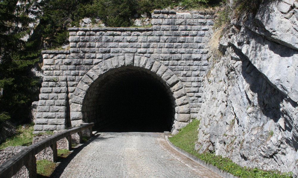
The Südwestunnel (Hochlenzertunnel)
As the work involved boring downwards, additional work was also required to ensure the correct elevation at the tunnel’s exit: large amounts of rock were transported to keep the slope manageable, and in spite of this unexpected addition to the route the project remained on schedule.
At one-hundred and fifty metres long, five metres wide and four and a quarter metres high, the construction of the Südwesttunnel was probably the toughest phase of the Kehlsteinstraße project. Dressed with limestone brick and insulated with both galvanised corrugated iron and specially-prepared mortar from the Swiss Sika concern, it was arguably the most impressive part of the entire road – the enchanting mountain views notwithstanding.
Hundreds of workers toiled throughout what would be a very wet summer to keep the project running smoothly, and the result was arguably one of the biggest feats of engineering during the entire construction process – even more perhaps than the Kehlsteinhaus itself.
That the Südwesttunnel was built at all is testament to the quality work of those tasked with its construction.
The Workforce
Owing to the aggressive timescales, upwards of three and a half thousand labourers had been brought in to carry out the work. While there were a number of unskilled labourers in the work gangs scattered around the busy mountain, the majority of these men were be ordinary construction workers, but highly-skilled experts well-drilled in alpine conditions. Local workers were joined by those from all over Germany and neighbouring Austria, and specialist stonemasons and artisans were also brought in from Italy.
The construction work would not be without its problems: falling rocks were perhaps the biggest danger to the armies of workers stationed along the length of the route, and on 10th August 1937 five workers were killed during a landslide close to the Berchtesgadener Blick and Südwesttunnel.
During the winter months, workers would have to cope with heavy snowfall and the buildup of ice, as well as the risk of sudden avalanches: on 30th January 1938 a worker’s convoy was engulfed by falling snow, and it was something of a miracle that there were no casualties. Two workers had managed to haul themselves out of the snow, while a third was rescued by Wilhelm Hauser, a labourer from nearby Bischofswiesen. ![]()
![]() Did You Know?In all, there would a total of eight fatalities during the entire construction period, one of whom was a worker stabbed to death by a colleague over an unpaid bet.
Did You Know?In all, there would a total of eight fatalities during the entire construction period, one of whom was a worker stabbed to death by a colleague over an unpaid bet.
Detractors of the Kehlsteinstraße project have often attempted to pass off the claim that slave labour had been utilised during its rapid construction, and it needs to be made absolutely clear that this was not the case. While the project deadlines were indeed aggressive, everyone who worked on it did so with a sense of professional pride; there is no evidence of any sort to suggest that slave or concentration camp labour had been used.